Alabama is facing storms today that have the potential to be significant, and a Level 5 out of 5 risk has been added for part of the state in the latest update from NOAA’s Storm Prediction Center.
Saturday’s storms could come in two forms — individual supercell storms in the afternoon and then a squall line of storms later in the evening.
Here is full coverage of Alabama’s severe weather threat
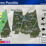
Below is the severe weather outlook for Saturday — now with areas in a Level 5 risk in pink:

Severe weather is increasingly likely for the entire state of Alabama on Saturday. A rare, Level 5 out of 5 risk has been added for part of the state in the latest update on Friday afternoon. Most of the rest of the state is in a Level 4 of 5 risk, which means that numerous severe storms are expected. Storm Prediction Center
Saturday: Severe weather is more likely on Saturday. Severe storms could get going as early as 11 a.m. Saturday in north Alabama and track eastward through the afternoon.

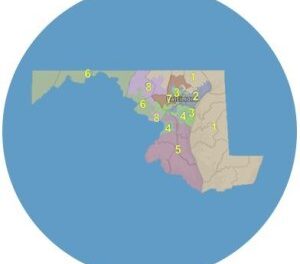
Here’s the north Alabama outlook for Saturday. NWS
The northern and eastern part of the region will have a Level 3 risk, and the southern part will have a Level 4 risk.
Saturday: Part of central Alabama has also been upgraded to a Level 5 risk on Saturday, including the Birmingham and Tuscaloosa areas. All of the rest of central Alabama will have a Level 4 risk on Saturday.
Storms could reach the western part of central Alabama by noon on Saturday and head eastward through the nighttime hours, exiting the state early Sunday morning.
Then forecasters expect a squall line to enter the state later Saturday afternoon into early Sunday morning.
Storms are expected to exit the state during the morning on Sunday, and calmer weather is expected through the first half of next week.


